[Reprinted from Ocean Magnetic and Electric Observations, 1915-1921. By J. P. Ault, S. J. Mauchly, W. J. Peters, L. A. Bauer, and J. A. Fleming. Carnegie Institution of Washington Publication 175, vol. 5 (1926). Page 13-22]
CRUISE VI, OCTOBER 1919 TO NOVEMBER 1921.
 |
| Plate 2 |
 |
| Plate 4 |
 |
| Plate 5 |
At the conclusion of Cruise V, June 30, 1918, the ocean-survey work was discontinued for the remaining period of the war. Dr. H. M. W. Edmonds continued in command of the Carnegie in Washington through December 1918 and had general supervision of the overhauling and dismantling of equipment and instruments. On December 31 he was relieved of command to take charge of and to prepare for the important work of acquiring a site and constructing the proposed observatory in Peru.
Mr. J. P. Ault resumed command of the Carnegie on January 1, 1919, and took up the general overhauling, repairing, and outfitting of the vessel for the resumption of the ocean-survey work. A cruise of 2 years was planned to start in August 1919, as it was expected that the repairs and alterations would then be completed. The unsurveyed regions in the South Atlantic and Indian oceans were to be covered and the return made through the Pacific Ocean and Panama Canal to Washington. The route was planned to obtain a large number of secular-variation observations, and included, as finally arranged, calls at the following ports: Dakar, West Africa; Buenos Aires, Argentina; Jamestown, St. Helena Island; Cape Town, South Africa; Colombo, Ceylon; Fremantle, Australia; Lyttelton, New Zealand; Papeete, Tahiti, Society Islands; San Francisco; Honolulu, Territory of Hawaii; Pago Pago and Apia, Samoa; Rarotonga, Cook Islands; Balboa, Canal Zone; and return to Washington. Short stops were made also at Fanning Island and at Penrhyn and Manihiki islands, Cook Islands.
Early in 1919 it was decided to convert the Carnegie's engine to operate on gasoline instead of on producer gas. This change seemed desirable because gasoline can now be secured in all frequented ports of the world and because of the increase in efficiency and reliability of operation resulting from the use of gasoline instead of producer gas. In accordance with this plan, early in March 1919, the engine was shipped to Jersey City, where the remodeling was carried out by the James Craig Engine and Machine Works, the builders of the engine.
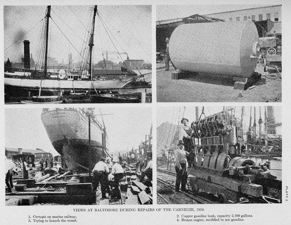
On April 18, 1919, the Carnegie left Washington under tow and arrived at Baltimore the following day. The vessel was overhauled and extensive repairs and alterations were undertaken under the direction of the Spedden Shipbuilding Company of Baltimore. The vessel was hauled out on Booz Brothers' marine railway May 13, 1919, and was resheathed with yellow metal and copper. This work was completed May 22, but upon attempting to haul the vessel down into the water again the cradle of the marine railway left the track and could not be moved (see Pl. 2, Figs. 1 and 3). Special launching ways were constructed, the careful planning and building of which extended over a period of 3 months, as practically all the work had to be done by divers. Every precaution was taken to insure the safety of the vessel during these operations. After numerous delays, the vessel was finally afloat again on August 21.
The Carnegie then returned to the Spedden Shipbuilding Company, where the remodeled engine was installed. For the storage of the gasoline, two copper tanks, each 6 feet in diameter and 10 feet long, were installed in the former producer room. Each tank carries 2,100 gallons of gasoline. Every care was taken in the construction of the tanks and in the installation of the entire power plant to insure safety in the storage and use of this fuel.
The installation of electric storage-battery for lighting and low power uses was an important addition. All fittings and fixtures were made of nonmagnetic material wherever possible, and twisted cable was used for the circuits. The 1-kilowatt, 40-volt generator, which was used to charge the storage-battery, was mounted in the after end of the engine-room, as far as possible from the positions of the observing instruments. This generator was operated by the 6-horsepower gasoline engine at times when magnetic work was not in progress. The 1-kilowatt generator proved too small for the work required and was replaced in March 1921 by a 2-kilowatt generator when the vessel was in San Francisco.
The delays in the completion of the gasoline tanks and in getting the Carnegie off the marine railway compelled a postponement of the sailing date from Washington until October 9.
Sailing from Washington October 9, 1919, the Carnegie proceeded down the Potomac to Chesapeake Bay, where the usual "swinging-ship" operations were carried out October 11. The vessel then proceeded to Solomons Island, where simultaneous observations of the potential gradient of atmospheric electricty were carried out on board and on shore with the vessel's sails in the various positions occupied during observations at sea. Here the Director of the Department joined the vessel for a final inspection. Upon the completion of the atmospheric-electric work, the Carnegie sailed for Old Point Comfort, where the Director bade farewell to the party. Mr. J. A. Fleming, then chief of the Magnetic Survey Division, and Dr. S. J. Mauchly, chief of the Section of Terrestrial Electricity, left the vessel to return to Washington after all matters in their respective charges had been arranged.
After a few days' delay at Old Point Comfort, during which a steward was signed on and 7 seamen were replaced, the Carnegie finally sailed from Hampton Roads, bound for Dakar, Senegal, October 19, 1919.
Soon after leaving Old Point Comfort the vessel encountered the usual Gulf-Stream weather, consisting of heavy winds from various quarters, accompanied by rain-squalls and wet weather. Similar weather continued all the way to Dakar with only a few pleasant days intervening. Two heavy storms were encountered but no damage was done to the vessel. Upon approach to the African coast, the usual northeast tradewind was replaced by winds from the southwest to southeast, making it necessary to keep well to the eastward in making the approach to Dakar. During the 4 days before arrival at Dakar heavy easterly winds, the harmattan, blew fine sand from the African desert, and moisture forming about the dust-particles developed into a fog which obscured the sun while below [10 degrees] to [15 degrees] of altitude. At the same time the horizon was nowhere more than one-half mile distant, which made navigation extremely uncertain and the approach to land particularly hazardous. Altitudes of the sun were measured from a position as near the sea-surface as possible and were then corrected for an estimated distance of the horizon. In spite of these uncertain conditions, the landfall was made as expected, and after standing off and on for 86 hours the Carnegie entered the harbor of Dakar under her own power when the haze lifted for a few hours November 22,1919.
On account of the presence of bubonic plague in Dakar, the Carnegie remained in that port only long enough to take on water and supplies, sailing for Buenos Aires November 26,1919.
Fair winds for the first 3 days were followed by 10 days of calms and light variable winds, during which time it was necessary to operate the engine. After safely rounding Cape Palmas, Liberia, the southwest monsoon was encountered, and it continued to blow from December 9 to December 18 as the Carnegie sailed southeastward into the Gulf of Guinea. Two days later the vessel entered the region of the southeast trade-wind, and for 11 days the daily run averaged from 125 to 188 nautical miles with fine weather and under good sailing conditions.
After leaving the trade-wind region, about 10 days were spent in crossing the belt of calms, variable winds, and storms before the vessel entered the River Plate. On each of the two nights before reaching the river a heavy storm or "tempestura," from the westward occurred, with heavy rain and strong and shifting wind. Landfall was made with the aid of star observations during lightning flashes of the receding storm as they illuminated the horizon. Buenos Aires was reached January 19, 1920.
During the stay of 33 days at Buenos Aires the work and equipment of the vessel was inspected by Mr. Fleming for the Director, whose contemplated visit had to be abandoned because of pressing matters at Washington.
Various repairs were also carried out and the different magnetic instruments were intercompared on shore. Through the efforts of the American ambassador, the Argentine Government, as during previous visits of the Carnegie, extended various courtesies and privileges to the vessel during her stay at Buenos Aires. These courtesies and the facilities afforded by the Argentine customs officials were very much appreciated. Two watch-officers, 1 cook, the mechanic, 7 seamen, and the 2 mess-boys were replaced here. On February 21, 1920, the vessel left for St. Helena.
A week of moderate winds was followed by a heavy gale on February 28 as the vessel entered the region of the "roaring forties." For 48 hours the vessel ran before the storm at the rate of 10 knots with only the goose-winged lower topsail set. She scudded in the heavy cross-sea, shipping wave after wave from stem to stern. As the vessel proceeded southward, the cold and disagreeable weather gave warning of the presence of ice. On March 3 and 4 four large icebergs were passed.
Gough Island was sighted March 8 and several very interesting hours were spent passing this lonely, uninhabited island of the South Atlantic. Large numbers of the wandering and sooty albatross were present around the island, indicating this as one of their homes. Several specimens were caught and examined.
The latitude as given for Gough Island seems to be in error by [3.4 minutes], our observations giving [40 degrees 15.8 minutes] S., instead of [40 degrees 19.2 minutes] S., as shown on British Admiralty chart No. 2228, for Penguin Islet.
St. Helena was reached March 27 after a remarkable trip of 35 days, during which the daily run averaged 151 miles. During the 7 days at St. Helena the Department's magnetic station at Longwood was reoccupied. Several trips over the island were taken by the party, during which the various places of historic interest were visited. After fresh water and supplies were taken on board, the Carnegie sailed for Cape Town April 3.
After 3 days of sailing in the southeast trade-wind, the region of variable winds and calms was entered. Considerable lightning accompanied by heavy thunder was noted during some of the heavy squalls encountered in the middle of the South Atlantic far from land. The region of the westerly winds and storms was reached April 11. Tristan da Cunha Island was sighted April 15.
The usual cycle of atmospheric-pressure changes with their corresponding storms and changes in the direction of the wind for these regions was experienced. With high pressure northerly winds blow, shifting to northwest and west as the pressure decreases. The more rapid the decrease the stronger the wind blows. At the lowest pressure-point the wind shifts to southwest and blows hard if the pressure increases rapidly, shifting to south and southeast as the pressure rises, finally jumping to northeast and north as the highest pressure-point is reached.
Cape Town Harbor was entered April 24 after 21 days at sea, during which the high average of 152 miles per day was made. Here the usual intercomparisons of instruments was made at the Department's former station near the Royal Observatory. Considerable repair work to the vessel was undertaken. The decks and outside of the vessel were recaulked, the two ranges were overhauled and rebuilt, and various repairs were made to the plumbing.
The people of Cape Town made the stay of the party very pleasant by their generous hospitality and by the many courtesies extended. The port authorities granted all privileges to the Carnegie during her stay, and various exemptions were made by the government officials in the matter of payment of towboat charges, customs dues, and immigration regulations. Opportunity is here taken to make grateful acknowledgment of these many courtesies.
On May 20 the Carnegie sailed for Colombo, this port having been substituted for Aden in the revised route instructions. During this trip 4 strong gales were encountered and heavy winds prevailed in general. The vessel spent 19 days in the region of the "westerlies," after which the southeast trade-wind was picked up with a few hours of calm intervening. After one week in the southeast trades, the southwest monsoon was encountered, and this wind continued until our arrival at Colombo. The route extended up into the Arabian Sea in order to cross the Carnegie's 1911 track and and to relocate the agonic line. While crossing this line 6 declination determinations were made in 25 hours with perhaps more than the usual accuracy in spite of the gale which was blowing.
At midnight June 26 the light on Minikoi Island was sighted as expected. Eastward of Minikoi the monsoon was very light, so that the Carnegie did not reach Colombo until the morning of June 30, after being hove to off the port all night. The distance covered from Cape Town to Colombo was 6,665 miles, giving a high average run of 163.4 miles for the trip of 40.8 days.
The trip from Cape Town was unusual in that declination observations were made daily in spite of the unfavorable weather conditions. Rain or precipitation of some kind occurred on 29 out of 40 days. On but 6 days were declination observations made only once, on 29 days they were made twice, on 3 days they were made 3 times, and on 1 day they were made four times, when relocating the agonic line. The chart errors in declination for the southern part of the Indian Ocean averaged over 1 degree, sometimes reaching 2.5 degrees. In the northern part they were less than 0.5 degree.
At Colombo an extended program of intercomparisons of instruments was carried out at the Department's station in the grounds of the Colombo Observatory. The use of the observatory was freely offered by the surveyor-general and by the director of the observatory, Mr. Bamford; the ready cooperation thus received and courtesies shown by the various officials greatly facilitated our work.
The vessel left Colombo July 24, the course being set for a point somewhat southwest of Java and thence generally southward to about latitude [33 degrees] south and longitude [85 degrees] east. Thence the vessel followed a track generally to the east and arrived at Fremantle on August 31. For 9 days during this part of the cruise continuous calm was experienced and the auxiliary power had to be used for a distance of 800 miles to get through the belt. Declination observations were made at over 50 stations.
The complete program of intercomparisons of ships' instruments was carried out at Cottesloe, near Fremantle. The land instruments aboard the Carnegie were also compared with the standards at the Watheroo Magnetic Observatory of the Department.
Upon the completion of the work at Cottesloe and at Watheroo, the Carnegie left Fremantle October 1 and after considerable difficulty in clearing Cape Leeuwin on account of heavy storms from the westward, followed a course to the south of Australia, reaching [54 degrees] south latitude and about [140 degrees] east longitude. Thence the course was shaped to the eastward for Lyttelton. On October 12 the Carnegie was within 1 mile of the charted position of the Royal Company Islands, [50 degrees 20 minutes] south and [142 degrees 50 minutes] east. Nothing was in sight for a radius of 40 miles with very good visibility. The Carnegie sailed eastward all day at about [50 degrees 20 minutes] south latitude and there were no signs of land. These islands have been searched for unsuccessfully by several navigators and have been omitted from nearly all the present navigation charts. Heavy northwest winds and seas prevented making Cook Strait, and Lyttelton was reached from the southward October 20. The total distance was 3,157 miles, making the daily average of 160 miles for the 20 days at sea.
The series of comparisons between the standard instruments of the Christchurch Observatory and those of the Carnegie were satisfactorily completed early in November; Mr. H. F. Skey, director of the observatory, extended every courtesy and facility for this work and took an active part in the observations. The Carnegie was towed out to sea November 19 and proceeded under her own power until after clearing Banks Peninsula, when all sails were set. For 3 days the wind blew from the north, then shifted to the west and remained westerly for 4 days. The 180th meridian of longitude was crossed November 22 and that date was repeated.
No heavy storms were met, but moderate gales blew on November 22, November 27, December 1, and December 5. From December 1 to December 10 the wind blew steadily from the northwest, driving the vessel about 600 miles east of her course. On December 14, on entering the southeast trade-wind, course was set for Papeete, which was reached December 23.
The total distance sailed from Port Lyttelton to Papeete was 4,262 miles, which gives a daily average of 122 miles for the 35 days at sea. Magnetic observations were obtained at 54 stations for declination and at 33 stations for inclination and horizontal intensity. Complete determinations of the 5 atmospheric-electric elements (potential gradient, conductivity, ionic numbers, penetrating radiation, and radioactive content) were made on 9 days; 4 elements were observed on 13 days; and three 24-hour series of diurnal-variation observations for the first three elements named were made. Shore observations to obtain secular-variation data were made at the Department's station of 1916 at Point Fareute. Some special work was also done in connection with the atmospheric-electric instruments.
The Carnegie left Papeete Harbor on the afternoon of January 3, 1921, in the midst of a heavy tropical rain squall. Fortunately the wind held more from the east than from the north during the entire run from Papeete, so that Fanning Island was sighted at 10 o'clock on the morning of January 14 from a good bearing, after being hove to 60 miles east of the island during the previous night. The vessel arrived off Whaler's Anchorage at 1h 25m p.m., and after tacking back and forth for two and one-half hours, during which time cablegrams were dispatched, departure was taken for San Francisco. The old Galilee station is no longer available on account of the extension of buildings and electric wiring; observations could not be made ashore, owing to the necessity of sailing that evening.
As the vessel was now leaking more than usual, it was considered advisable to proceed to San Francisco to dock for examination. The course was kept somewhat eastward of the one planned, so that it passed through the western Hawaiian Islands at Laysan Island instead of beyond the Midway Islands. From Fanning Island to Laysan there was no calm belt and no evidence of a proper northeast trade-wind. The easterly wind blowing at Fanning Island continued until after passing Laysan Island, often blowing from south of east. Laysan Island was passed at a distance of 1 mile on January 25. The position of the landing-place near the group of buildings, from the observations made on board the Carnegie, is: latitude, [25 degrees 46.1 minutes] north; longitude, [171 degrees 42.7 minutes] west of Greenwich. This position depends upon a latitude observation on Venus simultaneously with a longitude observation on the Sun in the afternoon two and one-third hours before passing the island, and upon latitude and longitude observations from stars 3 hours later, taken 10 minutes after the last bearing was obtained on the island, at a distance of about [1 1/3] miles. There was no evidence of a northerly or southerly current, and only 0.1 knot westerly set between the two observed positions. The longitude has been corrected for chronometer error determined after arrival at San Francisco. The position as given on the chart is [25 degrees 42.2 minutes] north, [171 degrees 44.1 minutes] west for the lighthouse, which should be near the landing-place as above. This shows the island to be 3.9 miles north of its charted position and 1.3 miles east. Soundings of 8 and 8.5 fathoms were obtained 1 mile off the southern end of the island, where, also numerous dark patches were noticed which seemed to indicate shallower water.
On January 28, in latitude [32 degrees] north, a northwesterly gale began which continued for 4 days and prevented making the desired northing. From February 1 to February 11 southerly winds and gales continued without interruption. Rough seas and consequent increase in leaking made it necessary to proceed under greatly reduced sail. Fine weather prevailed February 17, 18, and 19. A good landfall was made at 1 p. m., February 19, by bearings on Point Reyes and the Farallon Islands, and the anchorage in San Francisco Bay was reached at 10 o'clock the same evening.
Declination observations were made daily with the exception of 2 days. Unusually good weather was found near the California coast, so that declinations were obtained where previous cruises had failed to get them on account of clouds and fog.
The Carnegie arrived at San Francisco after 47.3 days at sea. The average daily run was 128.9 miles for the 6,099 miles traversed. Magnetic observations were obtained at 81 stations for declination and at 44 stations for inclination and horizontal intensity. Because of instrumental difficulties, the radioactive content was measured on 3 days only. The other four atmospheric-electric elements were observed on 21 days, and diurnal-variation observations were attempted on 6 days, on 3 of which weather conditions prevented a complete series.
At San Francisco the vessel was dry-docked, and such general repairs as found necessary on examination were made. Because of the short cruise planned before the return to Washington, when the vessel probably would have to be opened up for careful lamination and possibly might require extensive repairs before going out again, it was decided to copper-paint instead of resheathing the hull. The electric generator, was replaced by a 2-kilowatt generator, in order to make more adequate provision for the experimental work. Cylinder 4 of the main engine, because of a serious crack that had developed early in 1920, was replaced by a new phosphor-bronze cylinder.
Advantage was taken of the delay occasioned by the repair work to obtain complete standardizations of the ship's magnetic instruments at a new station, Fort Scott; the old station on Goat Island was found no longer suitable. Complete intercomparisons between substandard magnetometer-inductor No. 26, which had been brought especially for this work from Washington by Mr. Fleming, and the ship's standard land instruments were also made at Fort Scott. The results showed that the corrections for the ship's equipment had remained nearly constant.
Dr. J. C. Merriam, President of the Institution, made a personal inspection of the Carnegie on March 24.
The chief of the Magnetic Survey Division (Mr. Fleming), representing the Director, made an inspection of the vessel during February 24 to March 7, while she was in San Francisco, and took up various urgent matters with Captain Ault relating to instruments, equipment, and future work.
Upon the completion of the other shore work, capacity determinations were made for the conductivity apparatus, the radioactive-content apparatus, the ionic-content apparatus, and the penetrating-radiation apparatus.
The repair work and other business matters being completed, the Carnegie left the dock at 4 p.m. March 28 and sailed direct for Honolulu. During the entire passage observing conditions were good and permitted declination observations twice every day, except on April 1, when cloudy weather prevented them. Winds were moderate to fresh and favorable all the way. As the Hawaiian Islands were approached, the wind became quite strong and a very heavy current from the south was found in Kaiwi Channel between Molokai and Oahu Islands. The vessel arrived off Honolulu Harbor early April 12 and was alongside the dock at 8h 40m a. m.
The distance traversed was 2,222 miles, giving an average of 151 miles per day for the 14.7 days of the trip. Magnetic observations were obtained at 27 stations for declination and at 14 stations for inclination and horizontal intensity. Atmospheric-electric observations of the five elements were carried out on 3 days and of all elements except the radioactive content on 7 other days; 24-hour series diurnal-variation observations were made on 3 days.
The marked changes and improvements in the methods, instruments, and equipment provided for ocean observations since the cruise of the Galilee 16 years before were extremely gratifying. The Galilee made the passage from San Diego to Honolulu in 12 days during the year 1905, covering much the same region as the Carnegie covered in 1921. Thirteen stations were occupied then, as contrasted to 41 on the Carnegie's trip.
During the stay at Honolulu, a complete series of comparisons between the magnetic standards aboard the Carnegie and those at the Honolulu Magnetic Observatory of the United States Coast and Geodetic Survey was obtained. Additional capacity determinations were made for the ion counter, the radioactive apparatus, and the conductivity apparatus.
After completion of the comparisons at the Honolulu Magnetic Observatory, the Carnegie sailed April 28 and upon rounding the island of Oahu ran into the northeast trade-wind, which held until the parallel of [34 degrees] north latitude was reached. Westerly and northerly winds generally prevailed as the vessel sailed eastward along this parallel. On May 13 the northeast trade-wind was picked up again and then a southeasterly course was steered until May 21, when it was changed to a southwesterly one direct for the Samoan Islands. The Carnegie entered the region of the "doldrums" May 27 and left it May 29 with a light southeast wind which continued with variable force all the way to Pago Pago, but grew quite strong two days before the port was reached.
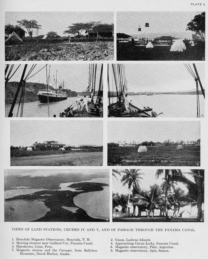
On June 12 a stop of a few hours was made at Penrhyn Island (See Pl. 5, Fig. 5), which is a typical coral atoll. The brief visit ashore was a welcome relaxation and enabled the party to secure some coconuts and Rarotonga oranges. A stop of a few hours was also made at Manihiki Island on June 15, and fresh fish, eggs, and coconuts obtained.
The Manua Islands were sighted early June 20, and by 6h 20m on the same evening the vessel was moored to the buoy in Pago Pago Harbor. After setting up the rigging and replenishing stores, the Carnegie left Pago Pago in the afternoon of June 28 and arrived off Apia the following morning. The total distance to Apia was 5,994 miles, which makes an average of 111 miles per day for the 54 days of sailing.
Winds were usually quite favorable throughout the passage, though never very strong; no storms were encountered and observing conditions were excellent. Declination observations were made on every day but one, usually twice a day. The total number of stations was 96; inclination and horizontal-intensity observations were made at 48 stations. On May 31 the vessel was swung for declination observations under fairly good conditions, the maximum rolling being [5 degrees] to starboard and [8 degrees] to port, and the ranges in the results were no larger than the indicated error of observation, [5 mintues] in the collimator results and [9 minutes] in the deflector results.
After official calls on the American consul and on the governor, arrangements were made for the work to be undertaken at the Samoa Observatory. The comparison of standards at the Observatory with those of the Carnegie was begun June 30 after consultation with Mr. C. J. Westland, then in charge of the observatory, and with the former director, Dr. Angenheister, who left Apia July 2 to return to his native country. Plans regarding continuance of the work in atmospheric electricity and regarding the past work and methods were discussed with Dr. Angenheister and Mr. Westland. Upon cabled authority from the office, and since some of the observatory apparatus was in poor condition, certain appliances for atmospheric-electric work were transferred from the ship to Dr. H. M. W. Edmonds for use at the Apia Observatory. A magnetometer, typewriter, and other equipment were also left at the observatory for Dr. Edmonds' use.
For facilitating the comparisons at the Apia Observatory, two new outside stations were established (see Pl. 4, Fig. 8), as the outside pier heretofore used for intercomparison work was found to be constructed of magnetic material. All ship instruments were also standardized. With the cordial and effective cooperation of Mr. Westland and of Dr. Edmonds the large amount of observational work was satisfactorily completed and the Carnegie sailed for the Canal Zone July 25.
It was necessary to depart from the track originally planned in order to land Dr. Pemberton for medical treatment at Avarua, Rarotonga Island, and allow him to return home. The vessel left Rarotonga August 15 and arrived at Balboa October 7. The Carnegietracks of earlier cruises were crossed 12 times and the Galilee track of 1908 was crossed once. These intersections (see Pl. 8) will yield important secular-variation data. A reversal of the usual currents was noted in the Gulf of Panama, the set being toward the south instead of to the north. Excellent results were obtained during the frequent observations of diurnal variation in atmospheric electricity. The average daily run was 124 miles for the 72 days between Apia and Balboa.
Secular-variation observations were made at Colon and a new magnetic station was occupied at Old Panama City. After dry-docking at Balboa the Carnegie proceeded through the canal and set sail October 20 for Washington on the last passage of Cruise VI.
A favorable southeast wind enabled her to make excellent headway towards Windward Passage, through which she ran on October 25 and 26 in a calm. Gales, or strong winds, then prevailed to November 6, when Cape Henry was sighted early in the morning. At 11 a. m., November 6, the Carnegie put in at Old Point Comfort and about an hour later proceeded up Chesapeake Bay to "swing ship" the following day at the same place as in 1919. "Swing observations" were made for the magnetic elements November 7 and the reduction-factor for potential gradient was determined off Solomons Island the next day. The results of the "swing magnetic observations" verified the absence of any appreciable "deviation-corrections" at the observing places aboard the Carnegie. On November 9 the Carnegie left for Washington, came up the Potomac with engine running, and docked at Smith's wharf at 5h 30m p.m., November 10. The total distance at sea was 1,975 miles, which was made in 17 days at an average daily speed of 116 miles
The Director joined the vessel at Balboa on October 12 for inspection of the work, and accompanied the party on the return cruise to Washington. Mr. R. R. Mills returned to the United States from the Canal Zone to resume his university studies. Dr. F. A. Franke was assigned to the ship's personnel at Balboa to take the place made vacant because of the illness of Dr. Pemberton.
The engine was operated very satisfactorily on many occasions throughout Cruise VI.
The total number of declination stations obtained during Cruise VI was 834, and the total number of horizontal-intensity and inclination stations was 439 for each element. The total distance covered from December 9, 1919, to November 11, 1921, was 64,118 nautical miles in 487 days at sea, making an average daily travel of 132 nautical miles. The average distribution of stations along the track of the cruise is very satisfactory, namely, one declination station for every 77 nautical miles, and one horizontal-intensity and inclination station for every 146 nautical miles. In addition to the magnetic work, atmospheric-electric observations were carried out regularly for 4 or 5 atmospheric-electric elements on each of 333 days, while diurnal-variation observations in atmospheric electricity were made on 36 days. In addition, roll-and-pitch records of ship's motion have been obtained frequently, and daily meteorological observations and various observations for determining geographic position have been made. Considerable time has been devoted to obtaining further data regarding performance of galvanometer and of earth inductor on board ship, as shown by the inductor observations, using the string galvanometer and the marine d'Arsonval galvanometer on alternate days; the work with the string galvanometer is not yet altogether satisfactory. Rock specimens were collected at ports of call for Dr. H. S. Washington's investigations at the Geophysical Laboratory.
The ship's personnel during Cruise VI was as follows: Dr. Louis A. Bauer, Director (October 12 to November 10, 1921); J. P. Ault, chief of the Section of Ocean Work, in command; H. F. Johnston, magnetician, second in command; Russell Pemberton, surgeon (until August 14, 1921); A. Thomson, H. R. Grummann, and R. R. Mills (until October 12, 1921), observers; F. A. Franke, surgeon (from October 12, 1921); A. Erickson, first watch-officer, C. E. Leyer, engineer; L. Larsen, second watch-officer (from February, 1920); F. Lyngdorf, steward; third watch-officer; 1 cook; 1 mechanic; 8 seamen; 2 cabin-boys; in all, 23 men.
The continued success of the ocean-survey work has been made possible in no small measure by the privileges and many courtesies extended the Carnegie and her staff by governmental and harbor authorities, as well as by men of science, at every port of call.